I love nature, I crave for it and I am the happiest in natural surroundings. So, it is not surprising that I look for nature trails for running and hiking every place I visit. I have been hiking for a while now and I have never blogged about my hikes, but my recent hike inspired me to write about it. My friend and I decided to do the Alamere Falls Hike in the Pt. Reyes National Seashore region. I had heard about this scenic hike to the tidefall and I wanted to see the spot where the waterfall tumbled on to the beach creating a beautiful sight. It had been on my bucket list since then and I had been yearning to go.
I researched online and looked up all the information on the trails and the hike and finally came up with a plan. The most tricky part of this hike was that it needed to be timed with tide timings as the high tide doesn’t allow for any space on the beach. This hike is also supposed to be extremely popular so we decided to go early which meant a 4.15am start from home as the drive was close to 2.5 hours for us.
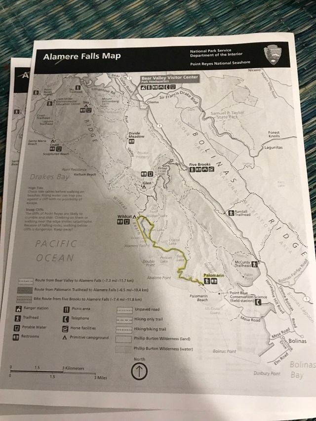
There are three trailheads that one can hike from to get to the falls, however we chose to do the most scenic and the longest hike from the Palomarin Trailhead. The trailhead is a little tricky to get to as it is in the little town of Bolinas off of Hwy 1. It is well known that the residents of Bolinas love their privacy and steal the street signs and markings so they can hide from the tourists. The road to get to Bolinas itself is unmarked and can be easily missed and we drove a few miles before realizing we had missed it. So read the directions carefully and print them out or take screenshots as we had done. There is no reception past Stinson Beach and that adds to the challenge. Eventually, we did make it to Palomarin Trailhead. Please be aware that the last mile to the trailhead is an unpaved, dirt path full of potholes etc. so drive slowly. Despite the 4.15 am start, we reached the trailhead at 6.50am and luckily we were the second car to park at the trailhead. After a quick restroom break, we were off on the Coast Trail to Alamere Falls.

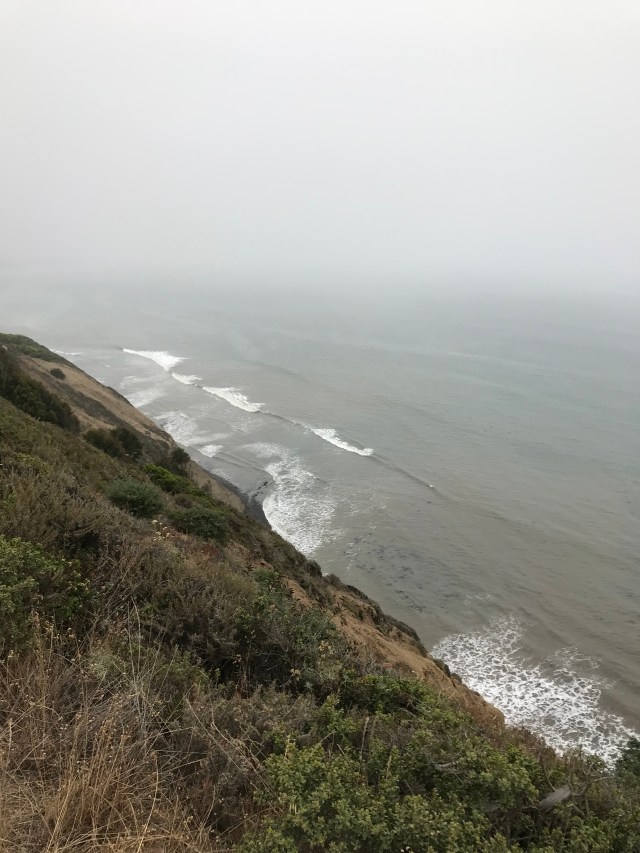
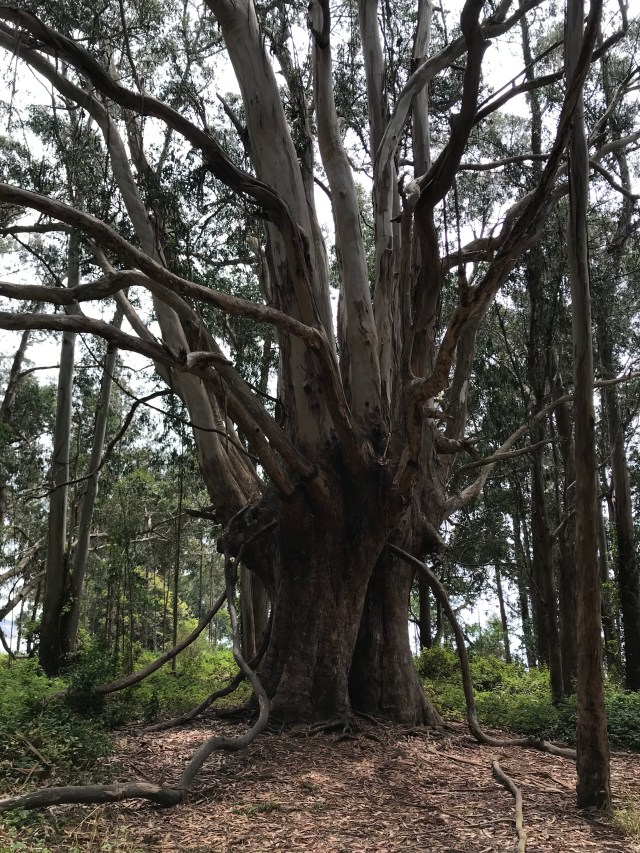
The trail starts off with a beautiful wooded path which goes through tall eucalyptus trees before opening to wide views of the coast and sheer cliffs.

At about 0.2 miles, stay on the right side of the path on the Coast Trail.

The trail meanders along the coast and goes through a pine forest, beautiful firs and cypress tree tunnels which make for a scenic trail.
The lush greenery with sweeping views of the hills on one side and the ocean on the other side make for some breathtaking views.

You can also see the fog rolling in the early morning hours. Due to our early start time, the trails were empty and we were able to soak in the nature and its beauty.


The trail goes past a couple wooden bridges over creeks and a couple ponds.
 As you continue on the trail, you reach a junction and stay on the Coast Trail.

Continue on the Coast Trail and you will reach Bass Lake at approximately 2.8 miles. There is a small trail that does go to the lake, but we decided not to go there as we were keen to get to the falls before the crowd came in.
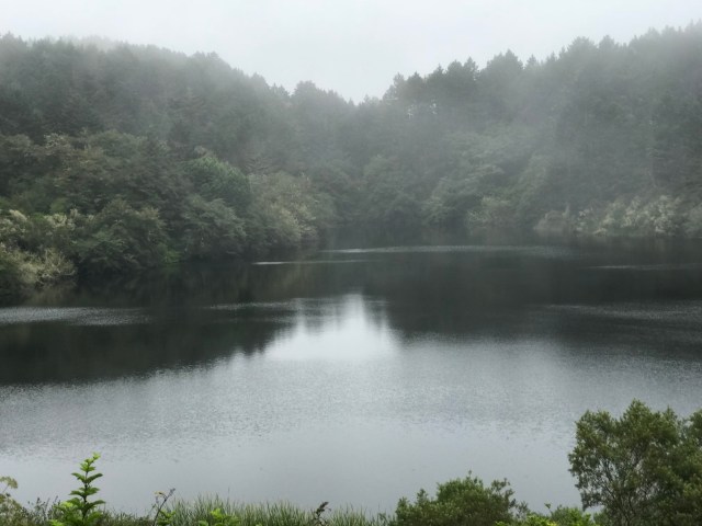 So we continued on the Coast trail going past another lake named Pelican lake towards the falls.

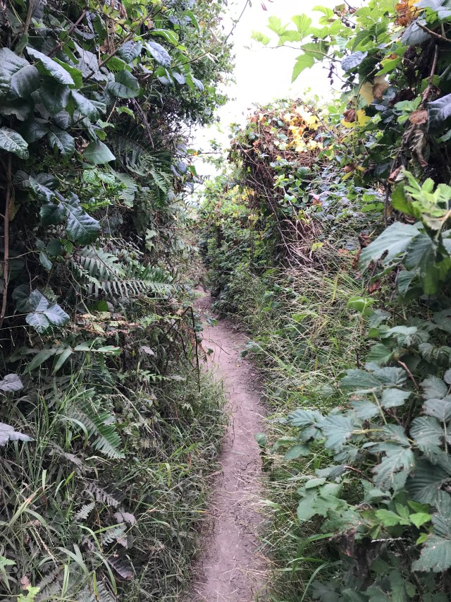
All my readings on the hike had mentioned that the longer route on Coast Trail to Wildcat Camp and then the 1 mile beach walk to the falls was safer, but there was plenty of information on the “shorter unmarked trail” which led to a steep incline to the top of the falls. Every post I had read on the so called shortcut talked about the safety risk of the steep incline and tried to deter the reader from taking it. However, for me sometimes the thrill and excitement overrides common sense and in this case the safer, longer path. I know patience is a virtue and I will be the first to admit that when it comes to adventures like these, I usually opt for the path less chosen. So here I was monitoring every gap and crack in the bushes to find the somewhat hidden trail leading to the falls. The narrow unmarked trail was actually very easy to find as someone had marked the trail with an arrow made of pebbles and small rocks.


No other signs were needed and we immediately tuned left. The narrow trail gave way to a nice wide trail in some areas, tree canopies and some areas where one had to walk in a single file.

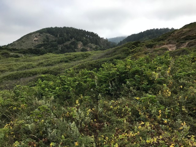
The trail also led to some sweeping views of the lush green hills before reaching a cliff side with views of the top of the falls and the beach below.

The incline is steep to get to the top of the falls and the path is narrow for one person only. The incline is steep but not as rocky and one can hold on to the rocks on the side for support.
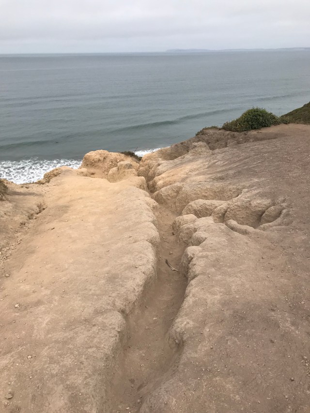 There are two paths to go down and the path on the left is steeper and narrower than the one on the right. One may find themselves sitting and scooting down on their bottom to get down. The first climb gets you to the top of the main waterfall and there are three tiers as the water drops down the hill side.


You will find that each tier has created a small lagoon and you can take a dip in the water.


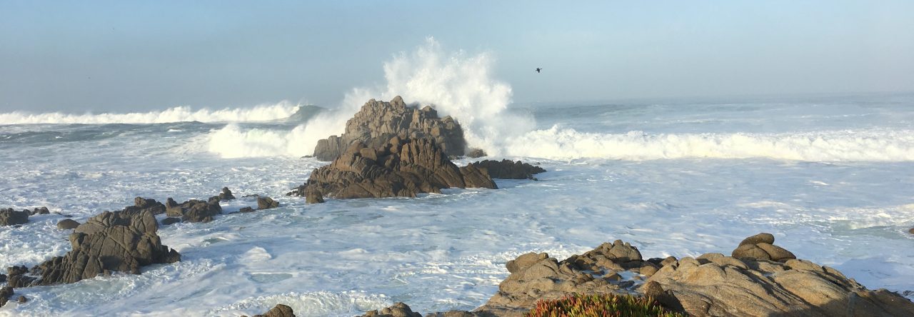
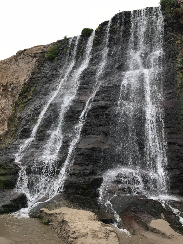
The water then flows down the cliff side to drop 40 feet to the beach. I even took my shoes off to dip my feet in the refreshingly cold water and after spending some time at the top and taking a food break, we started the descent down to the beach through the rocky incline.

Every word I had read warning about the dangerous climb down was true. The path to the beach is steep with loose gravel and rocks. You have to take care to make sure that the rocks you hold on to for support on the sides are sturdy and don’t give away under your hand and each step you take is steady. The loose gravel makes the downward climb dangerous as it is slippery.


My heavy backpack made the climb down a little challenging and so I decided to take it off and just slide it in front of me. The narrow path allows for only one person to go though so be prepared to wait in awkward spots and angles for faster people to get through. Slowly and steadily we made it down to the beach to a gorgeous sight. The water cascades down a 40 ft wall to the beach.

 We had plenty of opportunity to take pictures and enjoy ourselves. The fog had given way to the sun and after spending some time on the beach, we decided to climb up the incline.
 Taking the backpack off made the climb going up easier than the one coming down although arm strength is needed to pull oneself up. I came home to find my palms scratched up due to holding the rocks on the sides.
We back tracked the same Coast trail back happy to have made down to the falls and felt accomplished. As we walked back, we came across a continuous stream of hikers heading to the falls and considered ourselves lucky to have done the falls before the crowd got there. I shudder to think how we could have climbed down the steep incline amidst the crowd. By the time we made it to the car, the fog was rolling in again and we had completed 12.6 miles and 27,169 steps for me. As we got out of the parking lot, we realized that there were cars on both sides of the mile long dirt path making for some tricky driving and I felt relieved when we got on to the asphalt.
Tips:
- Check weather and tide timings before the hike as high tide will make it impossible to reach the beach.
- Wear protective gear as the trails are covered with stinging nettle and poison oak.
- Download and print all trail maps and directions as there is no reception after Stinson Beach.
- It may be a good idea to put your phone in airplane mode so that the battery does not run out.
- Take plenty of water and food. I took 2.5 liters and went through almost 2 liters.
- There is no restroom on the trail except the Palomarin Trailhead.
- The hike can be strenuous because of it’s sheer length
- Make sure to wear hiking shoes with treads to go down the steep incline. I would rate the difficulty of the incline as a 7 on a 10 scale.
- Enjoy the hike of course!! Take lots of pictures too 🙂

Solitude is what one seeks on such hikes and I get worried when I see too many people
Recently I had ro abandon my usual mountain for abother one as the former became too crowded
The trip must have been lot more fun than what has been documented
LikeLiked by 1 person
I look for solitude and crowds put me off. I set out early and many times choose the harder climbs as I know lesser people venture out. Luckily, I live in an area where the trails are mostly empty and I get my fill of nature 🙂
LikeLike